- Joined
- Jul 16, 2023
- Messages
- 3
- Reaction score
- 0
- Age
- 38
TLDR: Lost connection with drone upon takeoff but maintained video connection. Winds ~26mph according to phone app. Flight path likely took drone directly over cell phone tower. Ended up reconnecting with the drone after it was downed but it did not provide/provided false information on its whereabouts. Drone has not been recovered and is likely a loss. Hoping to reconcile what happened with Autel and the community. *Ultimately, after reading, can Autel help me recover the last known GPS coordinates of the downed drone - whether it be metadata or elsewhere?*
I don't know how else to get an all hands on deck but I need help and answers - mainly from Autel. My drone is still potentially recoverable but sadly it is set to rain today. I received my Autel Evo 2 Pro v3 on Thursday of this week (7/13) from AutelPilots. Yesterday, Saturday, (7/15) I almost immediately lost control upon takeoff with the controls becoming unresponsive but video feed remaining intact for a good amount of time.
Admittedly this is my first drone. With the amount shelled out for it, I was excited to get going with it. I read some pages out of my FAA manual Thursday night. Friday night I registered the drone, took the TRUST exam, and printed out my paperwork. Saturday morning I read the entire manual (had to read it on the iPad - the drone itself did not come with the manual). Right after that, I took my girlfriends daughter down the street to the basketball court and while she practiced riding her bike, I was in the air taking shots of a new housing development and using the "follow" feature on the gf's daughter (referred to as Kynslee from here on out) to show her what the drone could do. Fun experience.
Later on that day, we had a 60th birthday to go to for a good buddy of mine. The invitation said no gifts so I thought I would further my skills and get him some great shots of his 5 acre farm. We got to my buddies house and after some time Kynslee was bored and got upset that I was waiting to fly the drone - it was breezy to the point where I was concerned that I was going to have difficulty controlling the drone enough to get good shots or, admittedly, controlling the drone to the point where I would need to land anyway and try again later. I looked at one of the drone apps I had downloaded and it said wind gusts were 26 mph - not out of range for the >40 mph wind that I had seen the drone can handle.
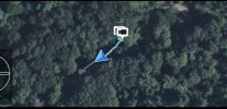
I gave in to Kynslee and got the drone out. I cleared the level concrete of any debris and took flight. My buddy's place is surrounded by trees. Almost immediately upon cresting the tree line (~100ft, I think less though?) I lost control of the drone in a south to north direction. It would not respond to controls but I had perfect video feed of my what now appears to be doomed drone. Had no control whatsoever - couldn't rotate, couldn't come down in elevation, it just tilted and almost immediately lost my LOS. Needless to say I start panicking. Everything I try is hopeless. I eventually see it cross an interstate - I can't tell you how much time had past because of all the things that were going through my head but I'm guessing 45 seconds to a minute.
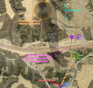
Very soon after that, the image froze to a black and white, so I assumed it was finally losing connection. I went over to a shaded area and took a picture of it with my phone that I plan to attach. I went into recovery mode after that. I analyzed the photo and compared the features to my google map - basically an hour-glass opening between trees with corn planted in between. I drove to the first similar feature that I saw - searched for about 20 minutes before realizing I was in a field of alfalfa, not corn. I looked at the map again and found another similar feature. Unfortunately with construction and the interstate - I had to drive 17 miles in order to get to a place that was about 2 miles away across the interstate. It just happens to be near an elevated lookout point - I thought it was fate in order to get a possible connection.
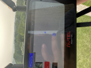
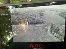
I make the drive on mostly gravel roads to get to the location. I go to near where feature is, near the lookout point, but couldn't get a connection and didn't want to go on private property without permission. I doubled back in my vehicle to the actual lookout point. I hiked the stairs to the top of it. Low and behold I got a connection to my drone!! I could even see the the image the camera was showing - a vertical branch and some sticks. It was at about 15% battery life. It showed it location in proximity to me, which was south/a few degrees southwest of my location. I hike toward that direction crossing the interstate (probably the interstate with the least traffic in Iowa). I go up the other side of the ROW which is directly in line with my buddies house, the assumed flight path and the cell phone tower I came too which marked private property. In one of the pictures I will attach, I am facing north to get a trajectory on where the drone is from the lookout point, and the cell phone tower is visible in the screen almost directly to the south. The icons were getting closer together on my controller as I moved towards the cell phone tower, but I could go no further due to private property, so I double backed across the interstate to my vehicle - barely made it, probably on the brink of heat exhaustion and dehydration - who cares at this point though I just want my drone back. Drank some water that I thankfully had in the car.
I drive around to go to back towards my buddy's house and on the opposite side of the cell phone tower where my remote control was indicating the drone was located (yes I took my controller with me when hiking across the interstate) Upon getting there I attempt to make contact with some homeowners. I never regained connection to the drone after leaving the lookout point - I assume the battery has died. This homeowner and I looked everywhere we could think of for the next 2 hours until we lose daylight, including around the cell phone tower itself.
The problem is (the problems are), the video showed the drone crossing the interstate. The area the controller was indicating and the homeowner and I was looking was on the south side of the interstate (which if the flight ended there means it didn't cross the interstate). The video clearly showed the drone traveling north over the interstate and the feature I saw as the last shot the drone delivered to my drone was on the north side of the interstate, and likely where the drone is at currently. Furthermore when I was on the lookout tower and had a connection - I could not do anything to my remote to change the map to tell me spatially where I was at in comparison to the drone itself. I had good Verizon coverage on my phone. The only thing the map would show is state lines - it would not changed to aerial. So If I was zoomed in to where my icon and the drone icon were starting to separate, there's no scale or aerial available. If I zoom out, the icons are on top of each other and I can only see state lines.
That was last night. I'm still trying to figure out what to do from here - if I should go back out and search, but I need to get this on a forum or in an e-mail to Autel. It's beginning to thunder at my location.
Some of my questions are:
- Why did I lose controller connection almost immediately, but maintained video connection?
- Are the two on the same frequency?
- Can the cell phone tower affect the control frequency? The drone likely flew directly over the cell phone tower in its flight path.
- Why couldn't I activate aerial imagery at the lookout point?
- Why would the drone location show that it was south of my location when it was actually likely north of my location?
- Why did the drone not communicate the last known GPS coordinates to my controller upon connection? This drone has so much technology on it it is almost offensive that I didn't have more in my favor to go with once I had worked so hard to make a connection with the drone after losing control of it. The flight path shows almost no information except for a time lapse - which I believe is 4 mins 30 seconds - I'll have to go and look.
- Can Autel help me recover the last known GPS coordinates of the downed drone - whether it be metadata or elsewhere?
I am open to any questions from the forum or Autel staff. I would really like to come to a solution with replacing the drone unit.
Update 1: Nearest major airport showing wind speed peaked at 12mph during the day and at the time of flying the drone with wind direction coming from WNW to NW. This means the drone was flying into the wind during its flight heading almost due north =( Source: Omaha, NE Weather History | Weather Underground
I don't know how else to get an all hands on deck but I need help and answers - mainly from Autel. My drone is still potentially recoverable but sadly it is set to rain today. I received my Autel Evo 2 Pro v3 on Thursday of this week (7/13) from AutelPilots. Yesterday, Saturday, (7/15) I almost immediately lost control upon takeoff with the controls becoming unresponsive but video feed remaining intact for a good amount of time.
Admittedly this is my first drone. With the amount shelled out for it, I was excited to get going with it. I read some pages out of my FAA manual Thursday night. Friday night I registered the drone, took the TRUST exam, and printed out my paperwork. Saturday morning I read the entire manual (had to read it on the iPad - the drone itself did not come with the manual). Right after that, I took my girlfriends daughter down the street to the basketball court and while she practiced riding her bike, I was in the air taking shots of a new housing development and using the "follow" feature on the gf's daughter (referred to as Kynslee from here on out) to show her what the drone could do. Fun experience.
Later on that day, we had a 60th birthday to go to for a good buddy of mine. The invitation said no gifts so I thought I would further my skills and get him some great shots of his 5 acre farm. We got to my buddies house and after some time Kynslee was bored and got upset that I was waiting to fly the drone - it was breezy to the point where I was concerned that I was going to have difficulty controlling the drone enough to get good shots or, admittedly, controlling the drone to the point where I would need to land anyway and try again later. I looked at one of the drone apps I had downloaded and it said wind gusts were 26 mph - not out of range for the >40 mph wind that I had seen the drone can handle.
I gave in to Kynslee and got the drone out. I cleared the level concrete of any debris and took flight. My buddy's place is surrounded by trees. Almost immediately upon cresting the tree line (~100ft, I think less though?) I lost control of the drone in a south to north direction. It would not respond to controls but I had perfect video feed of my what now appears to be doomed drone. Had no control whatsoever - couldn't rotate, couldn't come down in elevation, it just tilted and almost immediately lost my LOS. Needless to say I start panicking. Everything I try is hopeless. I eventually see it cross an interstate - I can't tell you how much time had past because of all the things that were going through my head but I'm guessing 45 seconds to a minute.
Very soon after that, the image froze to a black and white, so I assumed it was finally losing connection. I went over to a shaded area and took a picture of it with my phone that I plan to attach. I went into recovery mode after that. I analyzed the photo and compared the features to my google map - basically an hour-glass opening between trees with corn planted in between. I drove to the first similar feature that I saw - searched for about 20 minutes before realizing I was in a field of alfalfa, not corn. I looked at the map again and found another similar feature. Unfortunately with construction and the interstate - I had to drive 17 miles in order to get to a place that was about 2 miles away across the interstate. It just happens to be near an elevated lookout point - I thought it was fate in order to get a possible connection.
I make the drive on mostly gravel roads to get to the location. I go to near where feature is, near the lookout point, but couldn't get a connection and didn't want to go on private property without permission. I doubled back in my vehicle to the actual lookout point. I hiked the stairs to the top of it. Low and behold I got a connection to my drone!! I could even see the the image the camera was showing - a vertical branch and some sticks. It was at about 15% battery life. It showed it location in proximity to me, which was south/a few degrees southwest of my location. I hike toward that direction crossing the interstate (probably the interstate with the least traffic in Iowa). I go up the other side of the ROW which is directly in line with my buddies house, the assumed flight path and the cell phone tower I came too which marked private property. In one of the pictures I will attach, I am facing north to get a trajectory on where the drone is from the lookout point, and the cell phone tower is visible in the screen almost directly to the south. The icons were getting closer together on my controller as I moved towards the cell phone tower, but I could go no further due to private property, so I double backed across the interstate to my vehicle - barely made it, probably on the brink of heat exhaustion and dehydration - who cares at this point though I just want my drone back. Drank some water that I thankfully had in the car.
I drive around to go to back towards my buddy's house and on the opposite side of the cell phone tower where my remote control was indicating the drone was located (yes I took my controller with me when hiking across the interstate) Upon getting there I attempt to make contact with some homeowners. I never regained connection to the drone after leaving the lookout point - I assume the battery has died. This homeowner and I looked everywhere we could think of for the next 2 hours until we lose daylight, including around the cell phone tower itself.
The problem is (the problems are), the video showed the drone crossing the interstate. The area the controller was indicating and the homeowner and I was looking was on the south side of the interstate (which if the flight ended there means it didn't cross the interstate). The video clearly showed the drone traveling north over the interstate and the feature I saw as the last shot the drone delivered to my drone was on the north side of the interstate, and likely where the drone is at currently. Furthermore when I was on the lookout tower and had a connection - I could not do anything to my remote to change the map to tell me spatially where I was at in comparison to the drone itself. I had good Verizon coverage on my phone. The only thing the map would show is state lines - it would not changed to aerial. So If I was zoomed in to where my icon and the drone icon were starting to separate, there's no scale or aerial available. If I zoom out, the icons are on top of each other and I can only see state lines.
That was last night. I'm still trying to figure out what to do from here - if I should go back out and search, but I need to get this on a forum or in an e-mail to Autel. It's beginning to thunder at my location.
Some of my questions are:
- Why did I lose controller connection almost immediately, but maintained video connection?
- Are the two on the same frequency?
- Can the cell phone tower affect the control frequency? The drone likely flew directly over the cell phone tower in its flight path.
- Why couldn't I activate aerial imagery at the lookout point?
- Why would the drone location show that it was south of my location when it was actually likely north of my location?
- Why did the drone not communicate the last known GPS coordinates to my controller upon connection? This drone has so much technology on it it is almost offensive that I didn't have more in my favor to go with once I had worked so hard to make a connection with the drone after losing control of it. The flight path shows almost no information except for a time lapse - which I believe is 4 mins 30 seconds - I'll have to go and look.
- Can Autel help me recover the last known GPS coordinates of the downed drone - whether it be metadata or elsewhere?
I am open to any questions from the forum or Autel staff. I would really like to come to a solution with replacing the drone unit.
Update 1: Nearest major airport showing wind speed peaked at 12mph during the day and at the time of flying the drone with wind direction coming from WNW to NW. This means the drone was flying into the wind during its flight heading almost due north =( Source: Omaha, NE Weather History | Weather Underground
Attachments
Last edited: