Welcome, Autel Pilots!
Join our free Autel drone community today!
Join Us

What’s the highest elevation you can launch from?

HiloHawaiian

Well-Known Member
Joined
Aug 19, 2017
Messages
1,865
Reaction score
1,303
Location
Carefree AZ
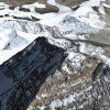
Yesterday, I launched from 11,000’, 80% up the side of Mauna Loa (the largest single mtn. mass on earth!). The XSP performed flawlessly, although the scenery was Mars-like devastation—all lava.

What’s the highest you can launch? Does Autel list a limit? Any Mainlander launch above 10,12,15k’? (Or whatever meters in Canada : D).

I’d try the 14,000’ Mauna Kea, but I’d probably get arrested, it’s a restricted telescope area...

A6FDD250-ED94-4C53-AD8F-5E69B6BAE5DB.jpeg 322899E1-BCFC-46EC-9D13-CA8F09582A4D.jpeg D95A9F5F-48EF-4A43-BD75-CB1093C842BB.jpeg
12162318-2E45-4EC8-BF3E-9FF062973456.jpeg
 
Very nice shots, but always check your sectional charts. Also, make sure you are at least 500 feet vertically under and 2000 feet horazontally from all clouds.
 
  • Like
Reactions: HiloHawaiian
Great Pictures!
I have a question that I need to ask and I definitely do not intent to be critical. I noticed that the horizon in the last shots were not level, is that caused by the horizon shift problem that some are experiencing after the last update?
Again, Great Pictures!
 
  • Like
Reactions: HiloHawaiian
Geez, thanks for the kind words. You are seeing the gentle slope of Mauna Loa. It’s almost 14,000’, but it’s so broad, it looks half that height from a distance. It’s a fountain Volcano, they don’t explode, they spew lava like a lawn sprinkler, spreading lava in all directions before it settles on the path of least resistance. You can walk to the top w/o any climbing gear. ML is active, 50+ years overdo... :eek:

Does this look like 14,000’?
18E47126-7A62-44F7-88C1-58BE1A3AC3CE.jpeg
 
  • Like
Reactions: tony.palumbojr
Ah, that's nice, but did you check your sectional charts? You are flying at 14000 feet?
 
When on top of mountain crests I reduce my flight height even less, down to about 100-150 ft. In sparsely populated areas many pilots will fly low, so I try to be aware of that possibly and stay cautious. Flying the mountains of West Virginia I’m not that high of course but generally around 4500 ASL. As stated by ASLWhite I would definitely check sectional charts because in sparsely populated areas aircraft will fly close, better to be safe than sorry.
Found this chart on another drone site...

Remember, the FAA numbers are guidelines and many situations may only need some common sense.
upload_2016-2-28_19-7-59-png.45346
 
Thanks, good advice! Mauna Loa is so odd, so wide at the peak, it’s confusing visually. It took 3 flights to feel kinda comfortable, but I still had the feeling my altitude was off, flying into the mountain even though I was at 400’. Reducing attitude did help, and keeping it closer-in did too. Flying high, pointed up-slope, was the most disorienting in that I couldn’t really tell if I was high enough to continue safety, even at max altitude...
 
Last edited:
Yes and I personally would keep it close as for up and down slope winds which at that attitude could be trouble for a small craft... just my two cents.

Happy and safe flying.... PS. Great photos
 
  • Like
Reactions: HiloHawaiian
Everest....... But
just before we brought it back in....... along came a Big Wind and blew it away. Gone, never to be seen again.
C H I T ! ! !


Attachments

  • 0A652A5E-A307-471E-A52F-9C74A7D14E62.jpeg
    0A652A5E-A307-471E-A52F-9C74A7D14E62.jpeg
    950.9 KB · Views: 25
  • Like
Reactions: tony.palumbojr
Everest....... But
just before we brought it back in....... along came a Big Wind and blew it away. Gone, never to be seen again.
C H I T ! ! !
Everest....... But
just before we brought it back in....... along came a Big Wind and blew it away. Gone, never to be seen again.
C H I T ! ! !
Wow! So the little guy died out there.
 
The FAA last time I studied this stuff, says you can fly at any altitude if your craft is less than 400 feet or less from a structure, which in this case could be the side of a mountain. So if you took off from a mountain top just to go horizontal, you could legally fly up and down it within the 400 feet range, unless there are other particular local rules in place.
 
The FAA last time I studied this stuff, says you can fly at any altitude if your craft is less than 400 feet or less from a structure, which in this case could be the side of a mountain. So if you took off from a mountain top just to go horizontal, you could legally fly up and down it within the 400 feet range, unless there are other particular local rules in place.

Yup thats right. Same goes for a very tall building, your allowed to go 400 feet above it legally.
 
When on top of mountain crests I reduce my flight height even less, down to about 100-150 ft. In sparsely populated areas many pilots will fly low, so I try to be aware of that possibly and stay cautious. Flying the mountains of West Virginia I’m not that high of course but generally around 4500 ASL. As stated by ASLWhite I would definitely check sectional charts because in sparsely populated areas aircraft will fly close, better to be safe than sorry.
Found this chart on another drone site...

Remember, the FAA numbers are guidelines and many situations may only need some common sense.
upload_2016-2-28_19-7-59-png.45346


Probably South West of you in Virginia lots of Military flights that are nap of the earth type. Unsure what this flight area is called now but it use to be "Oil burner" so probably changed to something else now. Had a B-52 fly under me one time when i was doing Forestry Service flights.
 
Don’t know...... so I’ll ask.
If I stand atop a 400ft condo and launch up to 400 feet..... will the altitude show 400 or 800 feet on the controller
 

Latest threads

Members online

Forum statistics

Threads
11,299
Messages
103,009
Members
9,912
Latest member
dandandan