Welcome, Autel Pilots!
Join our free Autel drone community today!
Join Us

EVO RTK Map Process with 4 GCPs and 2 CHECKPOINTS

Pasting points coordinates in WGS84 that i used for processing to be sure that we work on same data:
1,-115.217601,36.00308014,714.298
2,-115.2172625,36.0031074,713.906
3,-115.2169202,36.00311587,713.501
4,-115.2169195,36.00352983,712.808
5,-115.2172869,36.00359028,713.305
6,-115.2177631,36.00348732,714.107
GCP Label,Northing,Easting,Elevation (ft)
1,36.003080,-115.217601,742.236388
checkpoint2,36.003107,-115.217263,741.845938
3,36.003116,-115.216920,741.440858
4,36.003530,-115.216920,740.747741
checkpoint5,36.003590,-115.217287,741.243957
6,36.003487,-115.217763,742.044668

You are using the same X/Y but different Z values (approx. difference of 28)
 
from my experience between the 2 coord systems, the geoid is around 60' higher than ellipsoid
 
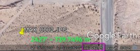
Looking at the exif data on a random image, MAX_424, it lists the height above MSL as 745 meters referenced to WGS84. The ground level in that image is approx. 738 meters. I think your flight height was higher than 7 meters so something is amiss with the drone's elevation #. What was your approx. flight height?

MAX_0424_exif.JPG
 
Actually, a quick look at the project location in Google Earth dictates that your elevation #s are probably closer to WGS84 than @elistechnology 's #s.
I am by no means any expert in this. I only know how to use my equipment and workflow and could be totally wrong.

The thing confusing me alot with this is:

Using a not too accurate elevation map of the area it seems the ground(orthometric height is around 740 meters.
But the elevations in the images are all around 740 meters. Shouldn't these elevations be around 740 meters + the altitude of the drone flight? Unless these elevations are height above ellipsoid. If they are height above ellipsoid, then the flight altitude should be around 90 to 100 feet?

From the GCP Excel sheet, I see there are several elevations given. Column D seems to be orthometric height in ft, column E seems to be orthometric height in meters (meters to feet conversion matches) and I think that column H is height above ellipsoid. This means that the Geoid in this area is around -30 meters since Orthometric height H = Ellipsoidal height h - Geoid n.

I will reprocess Pix4D assuming that the images have elevations based on the height above ellipsoid. And I will use the control points column H for heights above ellipsoid.
As DavePitman mentioned I will weight the Control Points and Image elevations the same as elistechnology.
 
  • Like
Reactions: Dave Pitman
The thing confusing me alot with this is:

Using a not too accurate elevation map of the area it seems the ground(orthometric height is around 740 meters.
But the elevations in the images are all around 740 meters. Shouldn't these elevations be around 740 meters + the altitude of the drone flight? Unless these elevations are height above ellipsoid. If they are height above ellipsoid, then the flight altitude should be around 90 to 100 feet?

I think you are correct that there is a transformation variable floating around in here that is skewing the #s. Without doing any math and just looking at the imagery, I would guess the flight height is closer to 130 feet, but that's just a WAG. Jeff will have to confirm. Perhaps the elevation corrections that were sent to the drone were not referenced to WGS84 but to the State Plane used (geoid)?
 
1633907711056.png
Flight height calculated by agisoft: 112ft

GCPs that @jmason702 attached to photos are exported from EMLIDs ReachView app (am i wrong?), ReachView always export points same way:

A B C D E F G H
Name, Easting, Northing , Elevation, Description, Longitude, Latitude, Ellipsoidal height, otherdatathatnotintrestsusasmuchrightnow

B, C, D - coordinates + heights set by user in project
F, G, H - WGS84 + elipsoidal heights

@jaja6009 Pix4D and mine Agisoft calculate similar and acceptable errors.
DroneDeploy missing something that Agi and Pix has.
 
What is the thought on this....
NTRIP is sending corrections in NAD State Plane, and the drone thinks it is receiving in WGS84. Isn't the shift now between WGS84 (Original) and NAD83 (2011) shifted a meter or two? And couldn't this shift on a curved ellipsoid be the offset he is getting in elevation? Not a large shift, but a shift. I only say this as on the Emlid forum when I was learning, I was told that the new Reachview 3 with its datum transformation support needed the datum going out to match the datum coming in. So if I wanted NAD83(2011) output, I needed NTRIP, VRS or setup on a known point to all be NAD83(2011).

Another point of concern... I think Drone Deploy when it see's his camera model, assumes that the elevations are AGL orthometric in EGM96. I will try to process in Drone Deploy tonight if I get a chance. (My school has the ridiculously priced Enterprise Version with all the bells and whistles.)
 
round 6
 

Attachments

  • Screenshot 2021-10-10 184330.jpg
    Screenshot 2021-10-10 184330.jpg
    242.3 KB · Views: 4
  • Round 6.jpg
    Round 6.jpg
    209.5 KB · Views: 5
  • round 6.5.jpg
    round 6.5.jpg
    146.6 KB · Views: 6
  • round 6.4.jpg
    round 6.4.jpg
    320.5 KB · Views: 5
  • round 6.3.jpg
    round 6.3.jpg
    291.4 KB · Views: 5
  • round 6.2.jpg
    round 6.2.jpg
    269.4 KB · Views: 5
I am not 100% sure what corrections the RS2 is sending to drone now that you bring it up. nothing in reach view tell me this. I know on this data set, I just set up base first thing let it get a fix. set up my gear, turn on RTK on the drone then it got its fix and flew the mission. I did not survey a point beforehand, even if I did, I have no way to tell what corrections it is sending to the drone.
 
But if you go back to page 2 the map I processed with just checkpoints, has an error of over 1000 inches in elevation. so there is no way the drone is getting corrections in state plane.
 
A map I processed using the RS2 with no ground or checkpoints
 

Attachments

  • Screenshot 2021-10-11 014627.jpg
    Screenshot 2021-10-11 014627.jpg
    411.2 KB · Views: 8

Latest threads

Members online

Forum statistics

Threads
11,332
Messages
103,246
Members
9,972
Latest member
Dave.Samuel